A Historical Narrative of Barrio la Victoria (Victory Acres)
Beginnings
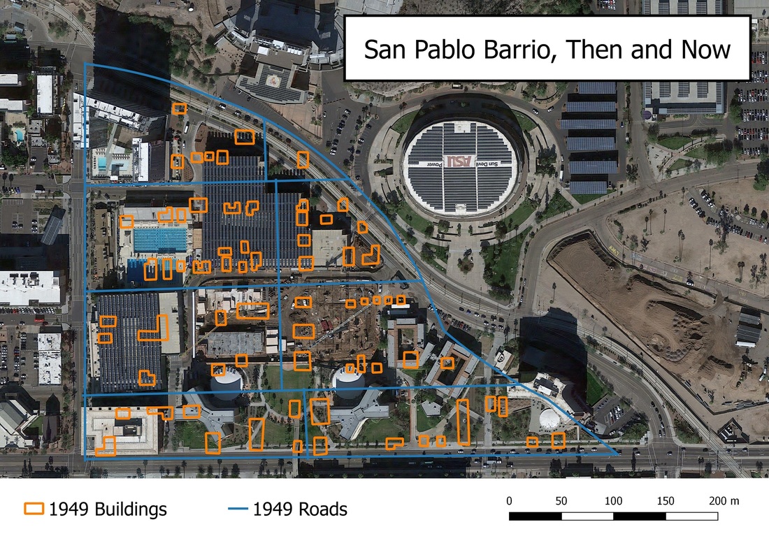
In the late 1800s a section of Tempe, Arizona was settled by Mexican immigrants. That area was known as San Pablo, and it became the main barrio of Tempe for the next few decades. It was a community of families until the late 1950s, when Arizona State University decided to expand.[1] At this point in history Arizona State University (ASU) aimed to build more dormitories for their main campus. As a result, San Pablo, a barrio that had “survived the Great Depression and two World Wars” was lost, and its citizens were relocated to other areas of Tempe.[2] One of the main areas of relocation was known as Victory Acres—or Barrio la Victoria to its residents.
Map showing changes in San Pablo between 1949 and now. Locations of structures and roads in 1949 San Pablo Barrio are superimposed on a current map of the area. San Pablo Barrio was razed to facilitate the expansion of Arizona State University. The majority of the displaced residents moved to the neighborhood of Victory Acres and created a new community there. Sources: Google Earth, Historical Aerials shared by Maricopa County. Made using QGIS 2.14.3 by Nancy Rushing, August 5, 2016.
Victory Acres has survived to the present day, although much of its look and atmosphere has changed in the past seven decades. The boundaries of this neighborhood run north to south from University to Apache, and east to west from Price to Evergreen, although there is a variety of information that has different boundaries listed, such as further south to Broadway, and east towards Dobson. The differences may point to the changes in the neighborhood over time, as modernization occurred.
Families in the neighborhood have “watched the area change from rural farmland to urban landscape.”[3] La Victoria began as a farming community when land was purchased by George and Mary Tibshraney in the early 1940s. By the mid-1940s they began subdividing their 80 acres of farmland and selling it off. One section of that farmland was named “Victory” Acres as a result of World War II and the winning attitude of Americans at the time. Many Mexican immigrants were coming to the area at this time in Arizona history because of the job opportunities, especially in agriculture. When being forced to relocate from San Pablo, Victory Acres—and its agricultural possibilities—was an attractive, and affordable, option.[4]
This community had humble beginnings, as “the first people in Victory Acres often lived in tents, or small, humble, adobe and wood homes. Eventually they expanded their homes as families grew, and later rebuilt their homes, especially with Tempe’s participation in neighborhood redevelopment in the mid-1970s and early 1980s.”[5] The city of Tempe eventually paved the dirt streets and improved the utilities of the community, creating a more livable neighborhood.[6] They were a tight knit community, along with the nearby Escalante neighborhood, shopping in a neighborhood market, going to church in the area—most were Catholics—and sending their children to local schools not far from the barrio.
General location map for Victory Acres within Tempe, Arizona
Changing Communities
Urban growth has played a major role in the changes to this neighborhood in the decades since its initial development. Aside from ASU expanding their campus over the years, a major freeway has been built running through Victory Acres, as well as the Valley Metro Light Rail transportation system that began service in 2009. One of the first major construction projects was the Loop 101 Freeway running through the west of the neighborhoods. According to an article in the East Valley Tribune, this freeway system—which began in 1988—was built through the center of the neighborhood, cutting it in half.[7] Nearly two decades later came the Valley Metro Light Rail system, with a stop on the western boundary of Victory Acres.
The community does not seem to profit from these urban developments, but rather, community members see them as a burden. Ramon Bello, a citizen of Victory Acres since the 1950s. He feels like the Price Freeway—the Loop 101—isolated the kids of the neighborhood. That, and the fact that the neighborhood lacks any city recreational facility for families, friends and kids to get together forces them to congregate outside in the streets of their community, which has caused the Tempe police to mistake their get-togethers as “gangs.” In fact, the neighborhood only has one small park within its boundaries.[8]
Present Day
Much of Victory Acres is now homes for its residents. The rural farming community that it once was has disappeared over the decades, leaving only memories in the minds of the residents who have continued to live in the area. Although urban development has been the cause for most of the changes in the area, very few businesses actually exist in Victory Acres. There are a few located along its northern boundary at University Drive, with a church near the center, but most of the buildings that remain are the houses of the people who call Victory Acres “home”.
Use the slider on the map below to compare changes from 1930 to 2016.
[1]Santos C. Vega, Mexicans in Tempe, (Charleston, SC: Arcadia Publishing, 2009): 6.
[2] Mike Sakal, “History: All that Remains of Tempe’s Lost San Pablo Neighborhood,” East Valley Tribune, June 4, 2011, Accessed August 4, 2016. http://www.eastvalleytribune.com/local/article_2367858e-8e3c-11e0-a79c-001cc4c03286.html.
[3] Santos C. Vega and Jean Reynolds, Victory Acres & Escalante Neighborhoods: Historias de la Comunidad: Stories from the Community, (Tempe, AZ: Braun Sacred Heart Center, 2004): 10.
[4] Ibid.
[5] Ibid.
[6] Ibid.
[7] Sakal, 2.
[8] Santos C. Vega and Jean Reynolds, 21.
